Catálogo - LIBROS NÁUTICOS - Navegación Costera y Astronómica
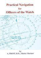
Practical navigation for officers of the watch
Autor: A. Frost
Editorial: Brown, Son & Ferguson
Año de edición: 2016 (2ª edición)
9781849270649
Encuadernación: cartoné
360 pág.
15,0 x 21,5 cm.
54,60€
Contenido:
"Practical navigation for officers of the watch" replaces the title "Practical navigation for second mates". The scope has been extended and includes relevant principles and theory to cover the requirements of the International Convention on Standard of Training Certification and Watchkeeping for Seafarers related to the use of charts and other Admiralty navigational publications, chart constructions, visual and radar terrestrial navigation, and the use of celestial bodies for the calculation of compass errors and for position fixing.
This new second edition now includes modules on ECDIS, which has had such a fundamental effect on the practical application of the basic principles of chartwork-the sections on wich have been retained in full. A module on ARPA has been included to enhance the section on radar navigation wich forms such an important adjunct to the use of ECDIS.
All navigational aspects of planning and executing the voyage safely and successfully are included with worked examples, exercises with answers with all necessary extracts from nautical publications.
The modules on celestial navigation have been retained as they are not only still relevant to existing training standards, but cover a topic in wich it is becoming increasing difficult to maintain competence due to the ease in wich geographical position at sea is now available.
Índice:
Introduction. The passage plan
SECTION 1
Module 1. Latitude and longitude. Units of distance
Module 2. The use of charts and other navigational publications
Module 3. Compasses, compass errors. Courses and bearings
Module 4. Chartwork constructions. Allowance for wind and tide
Module 5. Position lines. Position fixing by terrestrial observation
Module 6. The sailings
Module 7. Tides, tide tables and other tidal information
Module 8. Radar navigation
Module 9. Automatic Plotting Aids
Module 10. ECDIS
SECTION 2
Module 1. The celestial sphere and the nautical almanac
Module 2. Time
Module 3. Compass error by astronomical observation
Module 4. Altitude and azimuth. Correction of altitudes
Module 5. Position lines from astronomical observations
Module 6. Latitude by meridian altitude
Module 7. Calculation of position lines from bodies out of the meridian
Module 8. Latitude by Pole Star
Revision exercises
Answers
Extracts from the nautical almanac
Index
Precio: 54,60 €, I.V.A. incluido (4%)
[ Volver ]


