Catálogo - LIBROS NÁUTICOS - Derroteros, Guías de Navegación y Guías de Turismo
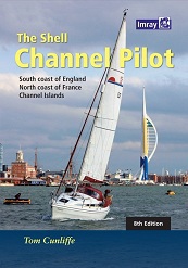
The Shell Channel Pilot
Autor: Tom Cunliffe
Editorial: Imray Laurie Norie & Wilson
Año de edición: 2017 (8ª edición)
9781846237003
Encuadernación: cartoné
454 pág.
21,5 x 30,5 cm.
57,65€
Contenido:
Esta Guía Imray comprende las siguientes zonas:
- Costa Sur de Inglaterra
- Costa Norte de Francia, y
- Islas del Canal de La Mancha
When all the websites and the almanacs have come and gone, The Shell Channel Pilot remains the ultimate authority on cruising both sides of the English Channel. Ever since the 1930s, when Adlard Coles published the original version, this seminal work has been steadily upgraded and updated. The three compilers who have looked after it since its inception have never tired. Under the Imray / Cunliffe house flag since 1992, it represents 80 years of effort.
This is the seventh Imray edition. The main text is organised into defined sections, each prefaced by comprehensive passage noted written by a seaman who has been there many times and wich lift the work far above a simple harbour guide. The pilot also includes a valuable "hand on the shoulder" for Channel navigation, as well as vital help with handling the incresing bureaucracy on both sides of the water.
The top-class pilotage notes, the plans, the aerial and approach shots for harbours great and small are unbeatable, while the author's sometimes alarmingly frank remarks about shoreside facilities, forewarning mariners of impending disappointments as well as guiding them to unexpected delights, have become a legend. As a guide and a shipmate, there is simply nothing like it.
Índice:
FOREWORD
INTRODUCTION
WILDLIFE AT SEA IN THE CHANNEL
COAST RADIO
I. THE ENGLISH COAST FROM NORTH FORELAND TO SELSEY BILL
Ramsgate
Sandwich
Dover
Folkestone
Rye
Eastbourne (Sovereign harbour)
Newhaven
Brighton
Shoreham
Littlehampton
II. SELSEY BILL TO SWANAGE - THE SOLENTAND APPROACHES
Chichester
Langstone harbour
Portsmouth
Bembridge
Ryde
Ventnor
Wootton Creek, (Fishbourne)
Cowes
Hamble River
Southampton
Beaulieu River
Newtown River
Yarmooth Harbour
Lymington
Kayhaven
Christchurch
Poole
Swanage
III. SWANAGE TO START POINT
Chapman's Pool
Worbarrow Bay
Lulworth Cove
Weymouth
Portland Harbour
West Bay (Bridport)
Lyme Regis
Beer
Axmouth
River Exe and Exmouth
Teignmouth
Torquay
Paignton
Brixham
Dartmouth
IV. START POINT TO BISHOP ROCK
Salcombre
River Yealm
Plymouth
Looe
Polperro
Fowey
Charlestown
Mevagissey
Gorran Haven
Falmouth and Falmouth Estuary (including Truro, St Mawes and Penryn)
Helford River
Coverack
Porthleven
St Michael's Mount
Penzance
Newlyn
Mousehole
Isles of Scilly
V. THE FRENCH COAST FROM DUNKERQUE TO CAP D'ANTIFER
Dunkerque
Gravelines
Calais
Boulogne
Etaples
St Valery-sur-Somme
Le Tréport
Dieppe
St Valéry-en-Caux
Fécamp
VI. CAP D'ANTIFER TO PTE DE BARLFEUR
Le Havre
Honfleur
Deauville / Trouville
Dives / Port Guillaume
Ouistreham / Caen
Courseulles-sur-Mer
Arromanches
Port-en-Bessin
Grandcamp-Maisy
Isigny-sur-Mer
Carentan
St Vaast-la-Hougue
Barfleur
VII. CAP DE BARLEUR TO CAP FRÉHEL, INCLUDING THE CHANNEL ISLANDS
Cherbourg
Omonville-la-Rogue
Alderney
Guernsey
Sark
Jersey
Diélette
Carteret
Portbail
Granville
Iles Chausey
Cancale
St-Malo / St-Servan
La Rance
St-Briac-sur-Mer
St-Cast
VIII. CAP FRÉHEL TO ILE D'OUESSANT
Dahouet
Le Légué (St-Brieuc)
Binic
St-Quay-Portrieux
Paimpol
Ile de Bréhat
Lézardrieux / C Pontrieux
Tréguier
Port Blanc
Perros Guirec
Ploumanac'h
Trébeurden
Lannion
Primel
Morlaix
Roscoff / Port Bloscon
L'Aber-Wrac'h
L'Aber-Benoît
Ile d'Ouessant (Ushant)
APPENDIX
I. Charts
II. Distances
III. IPTS - International Port Traffic Signals
IV. Glossary
V. Ferry Routes
INDEX
Precio: 57,65 €, I.V.A. incluido (4%)
[ Volver ]


